Hits: 253
WPCNR TRAVELIN’ MAN. By John F. Bailey. March 25, 2025:
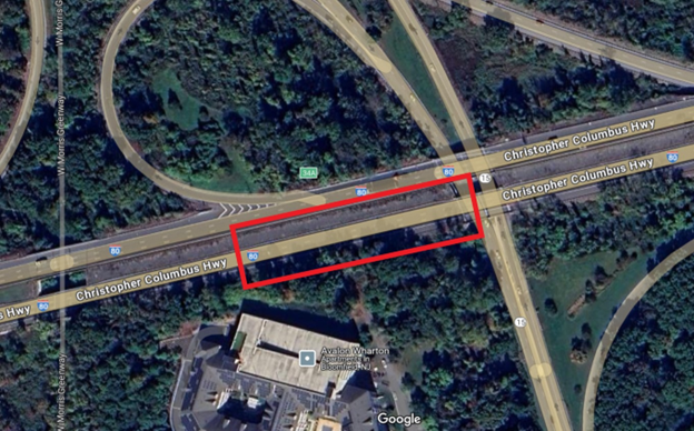
Brenda Starr and I went West today to a family reunion in The Caldwells, New Jersey. Now I had not been on Interstate 80 in a long time. As we approached Exit 52 for the Caldwells, I saw a very little sign saying “Detour Exit 34” this seemed curious to me. When I got to the famous Cloverleaf Tavern in Caldwell, now 92 years old. It came up in conversation that I-80 was closed both east and west bound at that exit.
Who knew?
It has been closed since February 10! Since I do not commute and go everywhere I have to go via Zoom, I do not listen to traffic reports.
I have to assume it is covered on the traffic reports. But then if you do not travel it regularly you may not know about it.
Let us assume I am the only one in the Northeast who does not know about it. So if there is anyone who is heading into New York on Interstate 80 on vacation or heading from New York on I-80
KNOW THIS: Do NOT take Interstate 80 to go way out west or travel the New York Metropolitan area.
You are detoured onto local roads at the Route 34 exit.
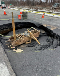
Why? Massive mines that the Interstate was built over have caved in, creating the world’s biggest potholes that make the roadway impossible.
This is a massive mistake in construction at the time the road was built.
This is News 12 meat.
Why is there not ongoing coverage and analysis on whether it is being corrected/repaired/rebuilt in the right way?
My suggestion: heading east or west may be to take the New York Thruway Westbound or Eastbound and take a southbound detour. If you are coming North to New York from the South…take the New Jersey Turnpike northbound, and the Pennsylvania Turnpike Eastbound.
Anybody have further suggestions on this major infrastructure error 80 years ago when this road was built send them to WPCNR@aol.com.
Jerseyans, my sympathies.
All we have to worry about in New York is Congestion pricing, horrible bumpy roads all over Westchester County and of course the drivers cowboying 20 miles (at least) over the speed limit, negligible enforcement of reckless aggressive driving.
Happy driving vacations everybody….and take the long way around.
Here is how the New Jersey Department of Transporation assesses the Interstate 80 mess as of today:
 Department of Transportation
Last Update: March 20, 2025
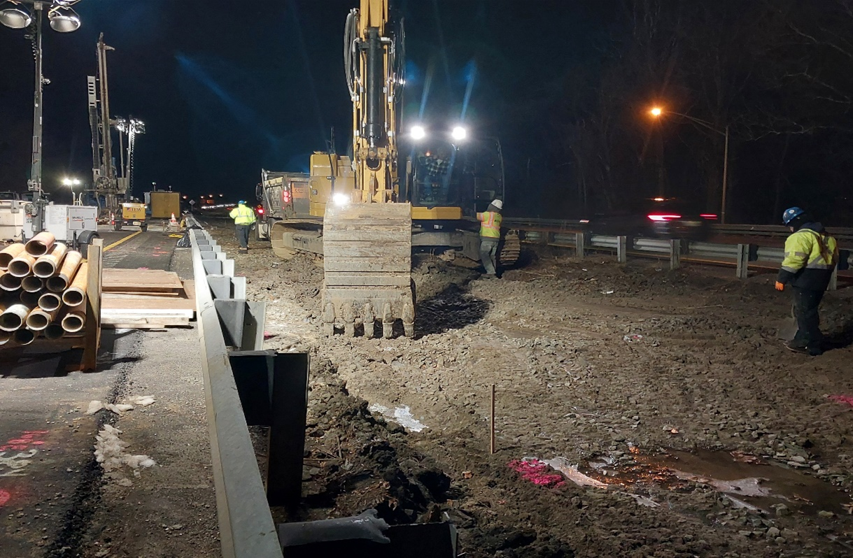
When the sinkhole developed in February, the Department immediately began a series of geotechnical tests on I-80 eastbound and westbound to gain an understanding of subsurface conditions.
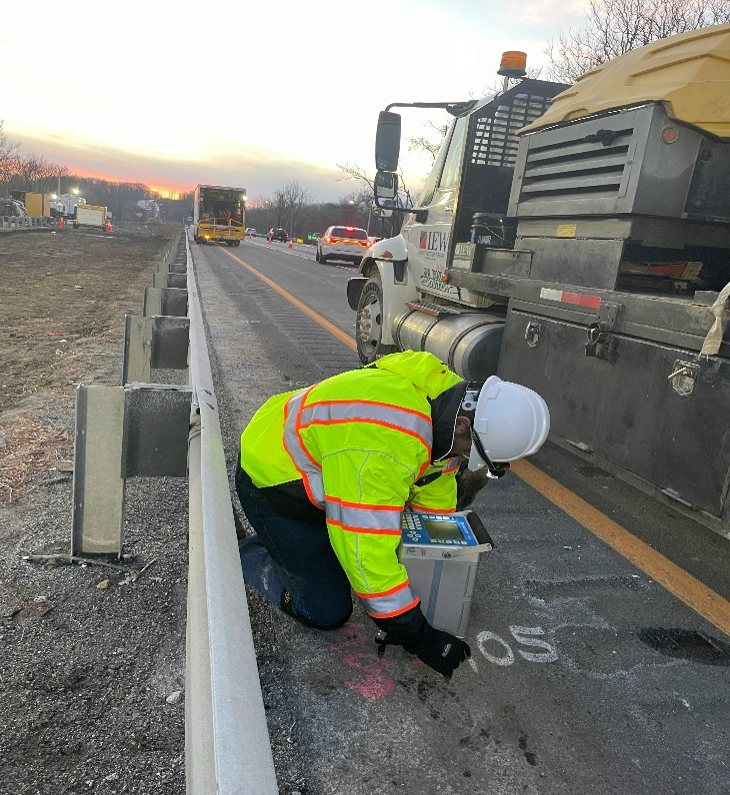
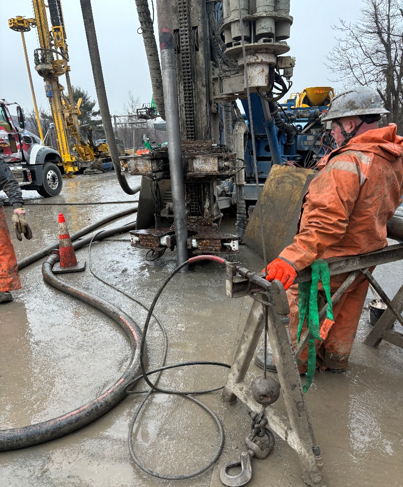
A drilling and grouting operation is ongoing to stabilize I-80 eastbound and to determine the area in which more extensive repairs are needed.
On March 19, an approximately 15-foot by 15-foot sinkhole opened up in the median in the I-80 eastbound work zone. Out of an abundance of caution, NJDOT immediately closed and detoured all lanes on I-80 westbound at Exit 34B/Route 15 northbound. Crews worked overnight to stabilize the area around the median sinkhole and are testing I-80 westbound to confirm the roadway’s integrity to determine what is necessary to reopen I-80 westbound. It has not yet been determined when I-80 westbound may be safe to reopen.
Once the drilling and grouting operations are complete, repair of a subsurface void will begin. This repair will be similar to the design implemented to repair the sinkhole in December.
MILESTONES
| Milestone | Status |
|---|---|
| Establish emergency detour route | Complete |
| Establish two-way traffic for residents | Complete |
| Revise Signal Timing to Improve Traffic Flow | Complete |
| Conduct Geotechnical Tests | Complete |
| Proactive Drilling and Grouting | Ongoing |
| I-80 westbound testing | Ongoing |
| Reopen I-80 westbound | To Be Determined |
| Sinkhole Repair | Has yet to begin |
| Quality Assurance Testing | Has yet to begin |
| Monitoring System Installation | Has yet to begin |
| Milling and Paving | Has yet to begin |
| I-80 eastbound Reopens | To Be Determined |
EMERGENCY REPAIR PHASES
The path to completing emergency repairs and reopening I-80 eastbound has several phases.
The timing for each phase has not yet been determined. However, the entire repair is expected to take approximately two months:
- Geotechnical tests to assess the condition of the roadway base are complete. These tests established our work area and helped identify approximately 150 locations to drill and grout.
- Drilling and grouting operations to probe subsurface conditions are expected to be completed in mid-April. This work is stabilizing the area under the roadway by filling holes and small voids and outlining the area where a more extensive repair is required.
- Repairing the sinkhole will be the next phase. The repair will be similar to the design implemented in December. It will include excavating the area, installing a base of large stone with a wire mesh on top. More stone and a concrete layer will go over the wire mesh. Additional fill and soil will be placed on top of the concrete and compacted before several layers of asphalt will be applied to reconstruct the road.
- Quality assurance testing will be done while repairs are being made and following completion of the repair to ensure the long-term stability of the roadway and the integrity of the repairs.
- Installing a monitoring system to track surface and underground conditions will be done as part of the repair. There will be three types of monitors. Remote sensing technology on poles will scan the pavement for changes, while sensors beneath the road will detect early signs of subsurface movement. Deeper underground devices will monitor long-term soil stability.
- Milling and paving the work area for a safe, smooth driving surface and reopening the road is the final phase.
EMERGENCY FUNDING
Governor Phil Murphy declared a State of Emergency for Morris County on March 8 to enable access to Federal funding. The Declaration was one step in the process to apply for emergency federal funding from the Federal Highway Administration (FHWA). NJDOT is continuing to work with FHWA.
TRAFFIC MITIGATION
The Department is continuing to work closely with local officials and the New Jersey State Police to improve mobility along the detour and alternate routes in the region.
Due the significant impact of the closures, GPS and other map services may reroute traffic onto local roads that are not designed to handle commercial vehicles or increased traffic volume. This is particularly important for trucks as there are low bridges and weight restrictions on many roads in the area. Please remain on the designated detours or alternate routes. Follow all posted signs and regulations, and if you are approaching an intersection, please “Don’t block the box.”
In addition, the Department has adjusted the timing of signals on Route 15, Route 10, and Route 46, which serve as the detour and alternate routes, respectively. NJDOT and New Jersey State Police will continue to monitor traffic conditions and make adjustments as necessary to mitigate delays. We ask motorists to avoid the area, plan extra travel time, and be patient while repairs are ongoing.
NJDOT also is using technology to send messages to commercial truckers to provide information about the closure, detour, and alternate routes. The Department is also using digital messaging signs and working with our regional transportation partners to share information so drivers can make informed decisions about potential alternate routes to take.
DETOURS AND ALTERNATE ROUTES
I-80 eastbound traffic is being detoured at Exit 34. The following detour remains in place:
I-80 eastbound Exit 34 Detour:
Motorists on Route 15 southbound wishing to take the bridge over Rockaway River will be directed to:
- Motorists on I-80 eastbound are being directed to take Exit 34 to Route 15/Wharton/Dover/Sparta
- At the end of the ramp, stay right following signs for Route 15/Jefferson/Dover/Sparta/Picatinny Arsenal
- Stay in the right lane on North Main Street following signs for Route 15 North/Jefferson/Sparta
- Bear right toward Route 15 northbound/Picatinny Arsenal
- Stay left, following signs for Pondview Drive/U and Left Turns
- Using both lanes, make a U-turn at the Pondview Drive traffic signal and merge onto Route 15 southbound
- Stay left to take the exit to I-80 eastbound
I-80 westbound traffic is being detoured at Exit 34B. The following detour is in place:
I-80 westbound Exit 34B Detour:
Motorists on Route 15 southbound wishing to take the bridge over Rockaway River will be directed to:
- Motorists on I-80 westbound will be directed to take Exit 34B to Route 15 north/Jefferson/Sparta
- Keep left on Route 15 northbound
- Use the left two left lanes at Pondview Drive to make a U-turn onto Route 15 southbound
- Stay right to take the ramp to I-80 westbound
Note
Traffic is advised to use Exit 28 to take Route 10 eastbound or Route 46 eastbound as an alternate route to avoid the area.
Route 10 eastbound Alternate Route:
- Motorists on I-80 eastbound are advised to take Exit 28/Route 46 eastbound to Route 10/Ledgewood/Lake Hopatcong, which is several miles before the closure
- Continue on Route 46 eastbound
- Stay right to take Route 10 eastbound
- Take the exit to I-287 northbound
- Stay right to take the ramp to I-80 eastbound
Route 46 eastbound Alternate Route:
-
- Motorists on I-80 eastbound are advised to take Exit 28/Route 46 eastbound to Route 10/Ledgewood/Lake Hopatcong, which is several miles before the closure
- Continue on Route 46 eastbound
- Stay in the two left lanes to turn left at the traffic signal to continue on Route 46 eastbound
- Turn left onto Route 15 northbound in Dover, back to I-80
- Stay right to take the ramp to I-80 eastbound
OR
- Continue on Route 46 eastbound for about 12 miles and stay left for I-80 eastbound